Significant Exploration Potential
Goldrich has uncovered a widespread system of gold mineralization and more than 30 high-priority drill prospects across six square miles to date. Exploration has included airborne radiometric and magnometer surveys, geologic mapping, surface trenching, geochemical sampling and diamond/reverse-circulation drilling.To date 25 HQ-sized diamond drill holes and 39 reverse-circulation holes have been completed, totaling 22,100 feet (6,700 meters), testing six prospect areas along a four kilometer northeast trending belt. All prospects are associated with major shear zones and/or subsidiary faults. Details of the highest priority drill targets are described below:
Aurora Gulch Prospect
- Large soil gold-arsenic anomaly spanning ~1,200 feet (365 meters) across; underlain by carbonaceous gray to black schist
- Greenstone sills up to 75 feet (22 meters) thick exposed near the top of ridge
- Anomalous gold values have been found in soil, stream sediment and rock chip samples
- Mineralization occurs as pods and lenses of sulfide±quartz distributed within sheared and isoclinally folded black phyllite/ schist
| Target | DDH | From (ft) | To (ft) | Interval (ft) | Interval (m) | Au (g/t) |
| Aurora | LS-0062 | 49.0 | 52.0 | 3.0 | 0.9 | 5.32 |
| 350.0 | 355.0 | 5.0 | 1.5 | 4.39 | ||
| 475.0 | 480.0 | 5.0 | 1.5 | 6.57 | ||
| LS-0063 | 56.0 | 59.0 | 3.0 | 0.9 | 4.44 | |
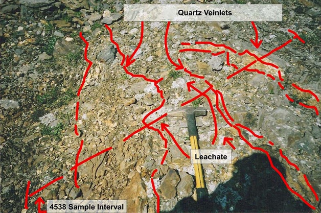
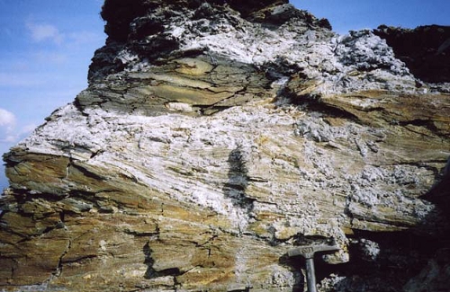
Above: Stockwork veinlet mineralization at Aurora prospect
Rock Glacier Showings
- Comprises several lobes derived from individual areas of intense mechanical weathering
- Quartz vein and altered vein breccia are found over an area covering 150 feet wide by 800 feet long (45 x 244 meters)
- Weathered float cobbles of dark quartz stained by As- and Fe-oxides contained massive arsenopyrite and other sulfides
| Target | DDH | From (ft) | To (ft) | Interval (ft) | Interval (m) | Au (g/t) |
| Rock Glacier | LS-0041 | 249.0 | 263.0 | 14.0 | 4.3 | 3.29 |
| including | 7.0 | 2.1 | 6.02 | |||
| 449.0 | 486.0 | 37.0 | 11.3 | 1.08 | ||
| LS-0060 | 475.0 | 480.0 | 5.0 | 1.5 | 4.17 |
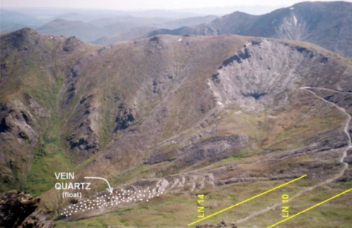
Above: Southwest lobe of Rock Glacier (foreground) mantled with quartz vein float
Mikado Shear Zone
- Zone can be traced for six kilometers and represents the most developed gold prospect in the district
- Shearing, faulting and silica-sulfide (gold) emplacement veins occur over total widths ranging from 82 to 213 feet (25 to 65 meters)
- Characteristics compare favorably to other lode districts containing large, bulk mineable gold deposits
| Target | DDH | From (ft) | To (ft) | Interval (ft) | Interval (m) | Au (g/t) |
| Mikado | LS-0049 | 256.0 | 259.0 | 3.0 | 0.9 | 4.58 |
| 378.0 | 381.0 | 3.0 | 0.9 | 4.46 | ||
| LS-0051 | 173.0 | 176.0 | 3.0 | 0.9 | 10.25 |
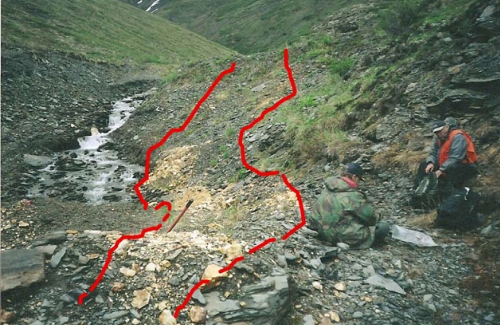
Above: Exposure of the Mikado structure on St. Mary's Creek at an elevation of 3,600 feet
Crystal Prospect
- Prospect consists of four parallel quartz veins
- Historic reports describe prospect shaft and grab sample of banded ribbon quartz veins assaying 43.2 ounces (1,344 grams) per tonne gold
- Additional samples of massive white quartz reportedly contained up to 0.99 ounces (31 grams) per tonne gold
Above: 5 foot (1.5 meters) massive quartz vein
Ratchet Ridge/Summit Prospect
- Located on ridge divide between Little Squaw Creek and Big Creek
- Adit has been driven on a poorly exposed 2.5-foot quartz vein and a nearby shaft is present
| Target | DDH | From (ft) | To (ft) | Interval (ft) | Interval (m) | Au (g/t) |
| Summit | LS-0044 | 79.0 | 128.0 | 49.0 | 14.9 | 1.12 |
| including | 28.0 | 8.5 | 1.70 | |||
| SUM-7 | 45.0 | 140.0 | 95.0 | 28.9 | 0.85 | |
| including | 20.0 | 6.1 | 2.63 | |||
| SUM-8 | 95.0 | 140.0 | 45.0 | 13.7 | 0.42 | |
| SUM-9 | 80.0 | 95.0 | 15.0 | 4.6 | 2.28 | |
| including | 5.0 | 1.5 | 5.52 | |||
| SUM-12 | 205.0 | 300.0 | 95.0 | 29.0 | 0.28 |
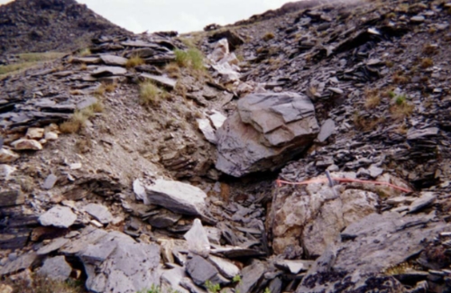
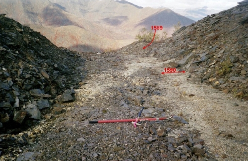
Above: Outcrop in cirque headwall of eastern extension of Ratchet Ridge gold-arsenic occurrence
Indicate/Tonopah Vein Fault
- Early-century mining of Indicate-Tonopah vein occurred across approximately 350 feet (160 meters) across of valley bottom
- Re-sampling of trenches in 1982 yielded 1.7 ounces (52.9 grams) and 6 ounces (186.2 grams) per tonne gold in grab samples
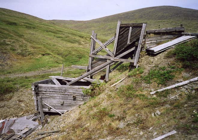
Above: Remains of Indicate-Tonopah mill
Pioneer Shear Zone
- Zone traceable across six miles; mineralization occurs in lenses of pulverized quartz, sericite and white clay
- Field reconnaissance collected three float samples collectively averaging 1.45 ounces (45 grams) per tonne gold
- Two trenches near the ridge crest have exposed shear zones and sheeted quartz veins up to 3 feet (0.9 meters) wide
Above: Prospect trench shows pinching and swelling pulverized auriferous quartz lenses part of a 25 foot (7.6 meters) wide zone
McLellan Prospect
- Prospect believed to be offset of Crystal prospect veins
- Five massive white quartz veins have been mapped running north-south over 600 feet (183 meters) measuring up to 20 feet (6.1 meters) in width
- Soil samples have assayed approximately 1.1 ounces (34.3 grams) per tonne gold
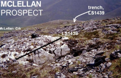
Above: Massive quartz veining is exposed in a trench at the McLellan prospect