Regional Geology
") The Chandalar district is part of a regional Devonian-aged Ambler Schist belt that extends 600 miles east/west across Alaska along the southern flank of the Brooks Range. The geology is made up of sedimentary, volcanic and intrusive igneous rocks that have been variably metamorphosed, sheared and deformed. Lode veins are structurally associated with NW trending strike-slip faults considered late mid-Cretaceous in age. Both lode and placer gold mineralization occur throughout the district.
The Chandalar district is part of a regional Devonian-aged Ambler Schist belt that extends 600 miles east/west across Alaska along the southern flank of the Brooks Range. The geology is made up of sedimentary, volcanic and intrusive igneous rocks that have been variably metamorphosed, sheared and deformed. Lode veins are structurally associated with NW trending strike-slip faults considered late mid-Cretaceous in age. Both lode and placer gold mineralization occur throughout the district.
The Chandalar gold district is underlain by regionally metamorphosed rocks that are part of the southern Brooks Range schist belt. This east-west-trending belt of poly-metamorphic rocks extend across the southern Brooks Range from the Kobuk River basin to the upper Sheenjek River drainage about 50 miles (80 km) west of the Alaska-Yukon border.
Bedrock units that underlie the Chandalar district are assigned to the Coldfoot terrane, which consists of regionally metamorphosed, Proterozoic-to-Paleozoic, meta-sedimentary and minor meta-igneous schist. The Coldfoot terrane contains the ‘Ambler sequence’, which hosts world-class volcanogenic massive sulfide deposits in the Ambler River area more than 250 miles to the west.
Geologic interpretations of the Chandalar district were first reported by Brosge and Reiser (1964), who completed the first modern mapping of the Chandalar district at 1:250,000 and 1:63,360 scales, respectively. This work provided the first modern isotopic ages of igneous and metamorphic minerals in the southern Brooks Range and mapped a thrust surface within Devonian quartz mica schist in the Chandalar district. Rock unit descriptions and a geologic map from Chipp (1970) provide descriptions of the Chandalar district published at 1:40,000 scale. Chipp subdivided the rock units into Lower Plate and Upper Plate sequences, which are separated by a major thrust fault.
Further Reading:
1) Geology of the Chandalar Mining District, East Central Brooks Range, Northern Alaska, by Thomas K. Bundtzen
2) Gold Deposits of the Chandalar Mining District, Northern Alaska, by James C. Barker & Thomas K. Bundtzen
Local Geology
 The Lower Plate sequence consists of black schist, phyllite, slate, and quartzite intruded by diorite to gabbro sills or dikes. The black schist-dominant unit is in thrust contact with the overlying schist section in the Upper Plate sequence, which has been divided into five metasedimentary rock units which exhibit upper greenschist facies metamorphism. Intrusive and meta-igneous rocks are much less common in the Upper Plate than in the Lower. The topographically higher and better exposed Upper Plate hosts most known gold occurrences in the district, although several prospects, including the Pallasgren, are found in the Lower Plate.
In both plates gold-bearing veins and other structures are controlled by a conjugate system of west-northwest-, northwest-, and northeast-trending, high-angle, deep-seated faults which cut the metamorphic fabric and the principal Chandalar decollement, demonstrating that the structure-hosted gold is post-metmorphism and later than the thrust dominated tectonic regime.
Further Reading:
1) Evaluation of the Chandalar Alaska Mining Property, by James C. Barker, Robert B. Murray & Jeffrey O. Keener
Lode Mineralization
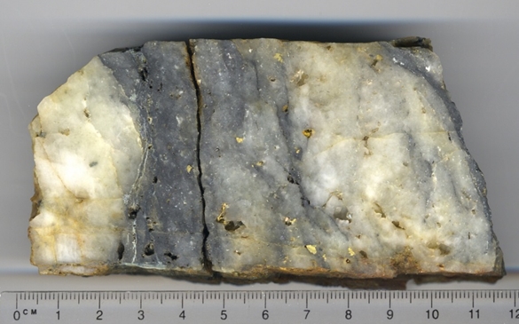 Lode gold deposits within the Chandalar district feature discontinuous quartz lenses and shear zone-controlled disseminations, stockwork, and sheeted veining. Primary vein controls are WNW high-angle shear zones that cut Devonian-age or older greenschist-facies metamorphic rocks considered part of the Coldfoot subterrane of Arctic Alaska.
Gold mineralization typically occurs as free gold in shear-hosted quartz lodes which have historically been interpreted as a metamorphogenic or orogenic deposit type. Currently, a number of features are now recognized which suggest a significant magmatic contribution to vein-forming fluids, suggesting that Chandalar formed as an Intrusion Related Gold System (IRGS). These features include:
- Numerous occurrences of pegmatitic textures in quartz-feldspar-mica-gold veins and veinlets;
- Common occurrence of euhedral high-temperature REE minerals (xenotime, monazite, thorite) typically associated with magmatic environments;
- Large magnetic anomaly beneath central portion of NE-trend of Chandalar showings, appears to indicate an intrusive system (Figs. A and B);
- A subtle but distinct area of elevated Th+/K+ ratios in surface geochemistry above the magnetic anomaly and central to the area of greatest mineralization, is a possible expression of intrusive bodies at depth;
- Oxygen isotope values (n=15) of massive quartz-gold lode veins and quartz from gold-bearing pegmatitic veins are similar, supporting a common origin for the two types. These values are consistent with magmatic conditions, with δ18O(vsmow) measurements varying from 15% to 17.3%.
- Chandalar is on the northern boundary of the Tintina Gold Province, which hosts a number of IRGS deposits, including Fort Knox, Dublin Gulch, Brewery Creek, and Ryan Lode.
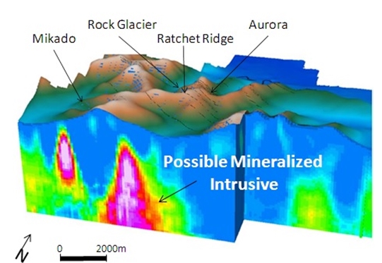
Figure A: 3D Inversion of magnetic data collected in 2014 by airborne methods reveals features at depth suggestive of an intrusive system of plutons and dikes, consistent with an IRGS source of Chandalar’s lode-forming fluids. These indications of buried intrusions form excellent drill targets in efforts to identify the source of Chandalar mineralization.
Placer Mineralization
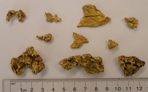 Placers of the Chandalar district occur in fairly steep, second- and third-order streams that contain an abundance of locally derived sub-angular to sub-rounded clasts of schist, quartz, and greenstone dike rock. The mountain ridgeline that separates the placer stream basins averages about 5,000 feet in elevation, and there has been significant down cutting of a former highland lying south of Squaw Lake.
Placer gold deposits in the narrow, incised upper creek valleys occur in pay streaks under 10-to-35 feet of overburden. At distances of two-to-five miles below the heads of the valleys, placer gold exploration has found depth to bedrock to exceed 170 feet with pay streaks on bedrock surfaces.
More Information:
1) Chandalar Placer Properties
Summary
The mineralization at Chandalar shares similar characteristics to many world-class deposits, one of which, Fort Knox, is in the same gold province. The IRGS and related types of deposits account for a major part of the world's gold production and constitute one of the most common and sought-after types of deposits in Canada, Brazil, Australia, and other regions in the world.